Bryce terrain color masks - how?

rampart_1576840087rampart_1576840087 Posts: 504
edited November 2015 in Bryce Discussion

I've not found how I can do this in Bryce.  When I export height maps I need color masks to describe 4 color/textures.

How do I do this, please point me to a tutorial or something.

I plan to use the Bryce to build quality terrians and then export height map and color mask and apply them in IClone.

The image map will be used and color mask will describe 4 terrain areas, including slopes, grounds, etc.

What I need to do is build the terrains in Bryce, identifiy the 4 terrain texture regions and ID them by Red-Blue-Green-Black color mask.

Then in IClone I apply textures applicatble to each of the different colors.  

I hope this explains. 


capture_001_05112015_142327.jpg
768 x 494 - 59K
Post edited by rampart_1576840087 on

Comments

  • It is not entirely clear to me what you are after.  Maybe it can be narrowed down.

    How are "the 4 terrain texture regions" defined?

    Is the colour mask to be in the form of a UV map or a 2d projection from above? 

    Though it is only for experiments there are a few videos here which touch upon the topic of terrain exporting.  And show how textures can be exported as projection image maps.

    Also consider this software by Horo http://www.daz3d.com/bryce-terrain-editor-advanced-filters which you might find useful to create advanced terrains.

  • rampart_1576840087rampart_1576840087 Posts: 504
    edited November 2015

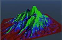
    This was basically a stab in the dark.  I can import height maps into Iclone, and I can import color masks for the outlay of textures on the height map.

    The colors are basically arranged similar to Carrara has them... for 4 different textures or mixes of textures.

    Red would be land/ground, blue would be second, greeen would be the third and black would be the fourth.

    In IClone I would be able to apply textures from IClone texture folders to apply to the various colors.

    Yes,  I can apply Carrara textures as I select and mix them in Shader tool, etc.  The twxtures will directly export from Carrara, when I create a mask.

    I am convinced the Bryce will produce much better terrains with the more advanced tools.

    I may be making something more complicated of this than necessary.

    There is so much I still don't know about Bryce, but I am learning.

    Post edited by rampart_1576840087 on
  • OK righto, got to start somewhere then, break the problem down into steps, what is the first thing you can't figure out?  And then maybe bit by bit we can build a picture up of the solution.  How far do you get in Bryce before you hit a wall?  Then hopefully I can explain how to get past that bit and tackle the next bit.

  • S RayS Ray Posts: 398
    S Ray said:

    Bryce terrain Editor does not support exporting colors. Altitude mask won't work. But you should be able to accomplish what you are trying to do in a photo editor. Here is an altitude render ( in Bryce ) using one of the altitude  material presets and the image map that drives it. You should be able to create a custom altitude map using any of the terrain altitude  materials presets as a guild. They can be exported in the material image library by coping the preview window and pasting in the image editor.   Probable need to apply the map planner to the front of your terrain in the 3D program it's imported to. Hope this works for You


  • S RayS Ray Posts: 398
    edited November 2015
    S Ray said:

    Bryce terrain Editor does not support exporting colors. Altitude mask won't work. But you should be able to accomplish what you are trying to do in a photo editor. Here is an altitude render ( in Bryce ) using one of the altitude  material presets and the image map that drives it. You should be able to create a custom altitude map using any of the terrain altitude  materials presets as a guild. They can be exported in the material image library by coping the preview window and pasting in the image editor.   Probable need to apply the map planner to the front of your terrain in the 3D program it's imported to. Hope this works for You


    Having trouble getting image map to upload


    Post edited by Chohole on
  • ChoholeChohole Posts: 33,604
    S Ray said:
    S Ray said:

    Bryce terrain Editor does not support exporting colors. Altitude mask won't work. But you should be able to accomplish what you are trying to do in a photo editor. Here is an altitude render ( in Bryce ) using one of the altitude  material presets and the image map that drives it. You should be able to create a custom altitude map using any of the terrain altitude  materials presets as a guild. They can be exported in the material image library by coping the preview window and pasting in the image editor.   Probable need to apply the map planner to the front of your terrain in the 3D program it's imported to. Hope this works for You


    Having trouble getting image map to upload


    You need to either attach it  or link from a site that supports hot linking, using the image button above the comment panel

  • S RayS Ray Posts: 398


    S Ray said:
    S Ray said:


    S Ray said:
    S Ray said:

    Bryce terrain Editor does not support exporting colors. Altitude mask won't work. But you should be able to accomplish what you are trying to do in a photo editor. Here is an altitude render ( in Bryce ) using one of the altitude  material presets and the image map that drives it. You should be able to create a custom altitude map using any of the terrain altitude  materials presets as a guild. They can be exported in the material image library by coping the preview window and pasting in the image editor.   Probable need to apply the map planner to the front of your terrain in the 3D program it's imported to. Hope this works for You

    Having trouble getting image map to upload


    S Ray said:

    Bryce terrain Editor does not support exporting colors. Altitude mask won't work. But you should be able to accomplish what you are trying to do in a photo editor. Here is an altitude render ( in Bryce ) using one of the altitude  material presets and the image map that drives it. You should be able to create a custom altitude map using any of the terrain altitude  materials presets as a guild. They can be exported in the material image library by coping the preview window and pasting in the image editor.   Probable need to apply the map planner to the front of your terrain in the 3D program it's imported to. Hope this works for You


    S Ray said:
    S Ray said:

    Bryce terrain Editor does not support exporting colors. Altitude mask won't work. But you should be able to accomplish what you are trying to do in a photo editor. Here is an altitude render ( in Bryce ) using one of the altitude  material presets and the image map that drives it. You should be able to create a custom altitude map using any of the terrain altitude  materials presets as a guild. They can be exported in the material image library by coping the preview window and pasting in the image editor.   Probable need to apply the map planner to the front of your terrain in the 3D program it's imported to. Hope this works for You


    S Ray said:

    Not having the ability to delete your own post is ridicules, why is daz forums still back in the 90's?


    S Ray said:
    S Ray said:

    Bryce terrain Editor does not support exporting colors. Altitude mask won't work. But you should be able to accomplish what you are trying to do in a photo editor. Here is an altitude render ( in Bryce ) using one of the altitude  material presets and the image map that drives it. You should be able to create a custom altitude map using any of the terrain altitude  materials presets as a guild. They can be exported in the material image library by coping the preview window and pasting in the image editor.   Probable need to apply the map planner to the front of your terrain in the 3D program it's imported to. Hope this works for You


    S Ray said:
    S Ray said:

    Bryce terrain Editor does not support exporting colors. Altitude mask won't work. But you should be able to accomplish what you are trying to do in a photo editor. Here is an altitude render ( in Bryce ) using one of the altitude  material presets and the image map that drives it. You should be able to create a custom altitude map using any of the terrain altitude  materials presets as a guild. They can be exported in the material image library by coping the preview window and pasting in the image editor.   Probable need to apply the map planner to the front of your terrain in the 3D program it's imported to. Hope this works for You


    Having trouble getting image map to upload


    Terrain1.jpg
    450 x 446 - 13K
  • S RayS Ray Posts: 398
    S Ray said:


    S Ray said:
    S Ray said:


    S Ray said:


    S Ray said:
    S Ray said:


    S Ray said:


    S Ray said:
    S Ray said:


    S Ray said:
    S Ray said:

    Bryce terrain Editor does not support exporting colors. Altitude mask won't work. But you should be able to accomplish what you are trying to do in a photo editor. Here is an altitude render ( in Bryce ) using one of the altitude  material presets and the image map that drives it. You should be able to create a custom altitude map using any of the terrain altitude  materials presets as a guild. They can be exported in the material image library by coping the preview window and pasting in the image editor.   Probable need to apply the map planner to the front of your terrain in the 3D program it's imported to. Hope this works for You


    Having trouble getting image map to upload

    http://www.daz3d.com/forums/uploads/FileUpload/df/cf1b318f55f09c0209357ee2dcd83a.jpg

    Not having the ability to delete your own post is ridicules, why is daz forums still back in the 90's?


  • S RayS Ray Posts: 398
    Chohole said:
    S Ray said:
    S Ray said:

    I attached it, after it uploaded ( before posting) all that was there was an X with no way to delete it, until after the thread was posted....then there is no way to delete the post.  The information needed is at the bottom of the tread


    Having trouble getting image map to upload


    You need to either attach it  or link from a site that supports hot linking, using the image button above the comment panel


Sign In or Register to comment.